| HOME | Reports and documents |
Fairbourne – Demolition of a whole village is a massive overreaction to a solvable problemMargaret HallOctober 2022 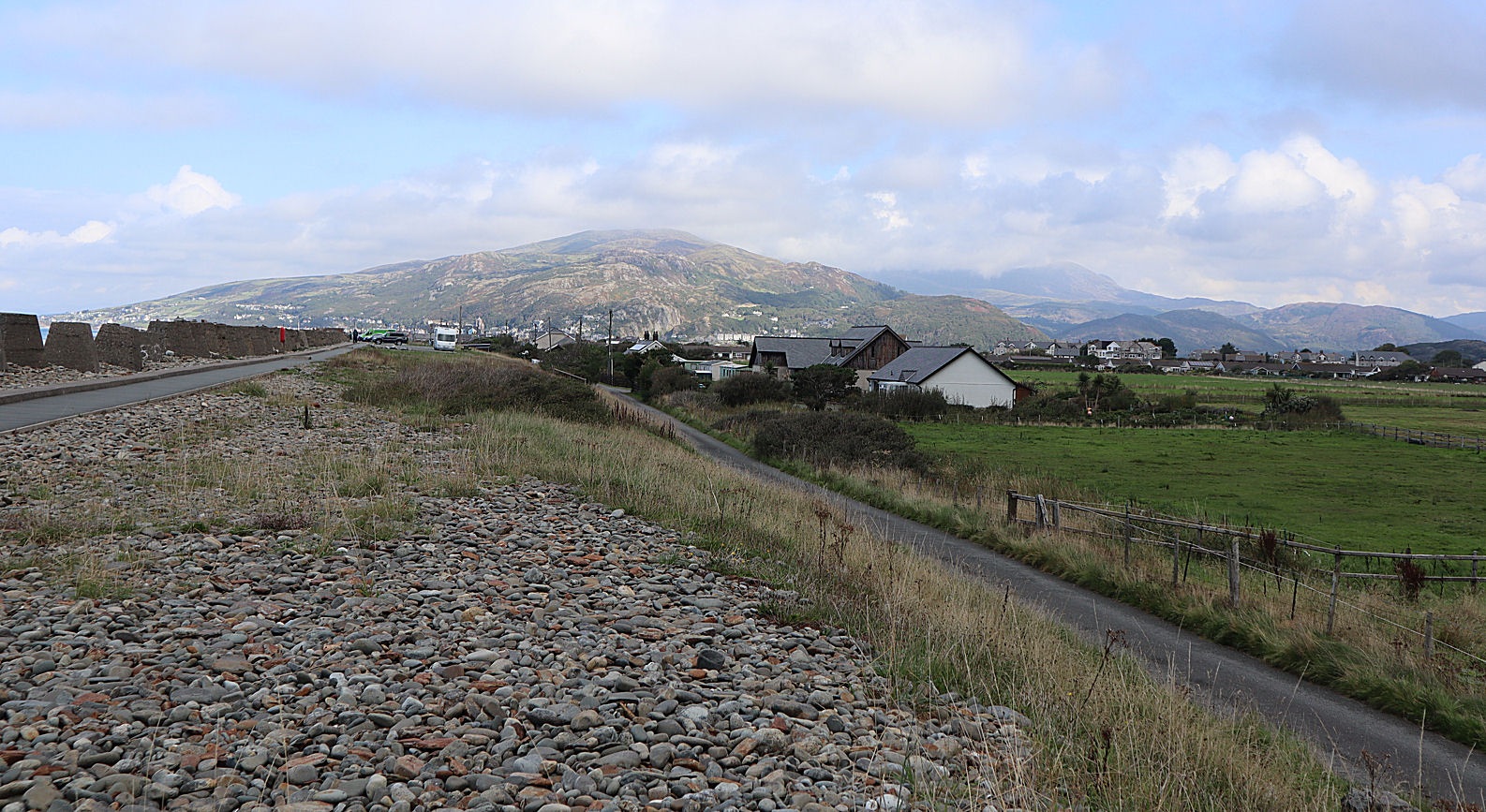
|
|
In 2014, the BBC broadcast an edition of the program "Week in Week Out" about sea level rise which focused on Fairbourne. It showed how Gwynedd Council intends to "decommission" the entire village, dismantling all homes, roads, shops, and infrastructure and turning it back into marshland, thus creating the UK's first "climate refugees". From this point onwards, Fairbourne, a small seaside village in the south of Gwynedd, has been chosen by the national media as the go-to example when talking about climate change in the UK.
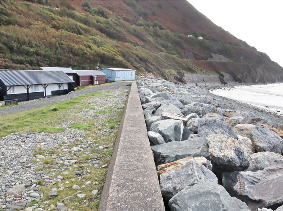
But has anyone paused to ask whether Fairbourne really is in any danger? The updated version of The West of Wales Shoreline Management Plan (SMP2) had been published the previous year. The report covered almost the whole Welsh coastline. Detailed research on individual locations was not done. The computer model used to reach the conclusion that Fairbourne would be drowned by rising sea levels was crude and inaccurate and has been disproved by recent events. The model predicted that by 2018 a major storm would inundate Fairbourne. However, while Storm Clara in February 2020 and Storm Eunice in February 2022 caused extensive flooding and damage to property across North Wales, Fairbourne remained completely dry. Despite this, Gwynedd Council continued to use the conclusions in the SMP2 report to justify their decision to decommission the village. Pleas from the local residents were ignored, as were two reports from independent scientists which showed that Fairbourne is in no significant danger. Finally, in 2021, a local hydrologist who had done his PhD on rainfall and flooding in the area was asked to look at the situation in more detail. It's cheaper to save Fairbourne than to demolish it Based on this new research and detailed computer modelling, a modest flood protection scheme costing under Ł10 million pounds was proposed that would keep Fairbourne safe well into the future. Meanwhile, the cost quoted by Gwynedd Council for decommissioning is Ł27 million, which seems like an underestimate as it includes no money for compensating residents who will lose their homes. So why are Gwynedd Council determined to press ahead with their scheme? The decision to decommission Fairbourne is clearly based on predicted costs. The price quoted by a major engineering company for combined works to provide protection for the village over the next 100 years has been estimated at around Ł115 million. Why is this figure so much higher than the cost of the flood protection scheme suggested by the people who actually have local knowledge? Computer modelling is an imprecise science and it appears that the huge estimated costs for keeping Fairbourne safe are based on an absolute worst case scenario for sea level rise and subsequent worst possible prediction of flooding. This situation has less than a 5% chance of actually occurring. Is this a sensible way to plan for the future? There is a photograph that almost always accompanies articles about Fairbourne's "climate refugees". It was taken in 2014 during a big winter storm. Waves break on the Ro Wen spit and appear to be washing over the wall and inundating the village. But look more closely and you will see that the flooded fields are well outside the village. The photograph actually shows Friog, not Fairbourne, where a few holiday chalets ended up surrounded by shallow water that did not enter the buildings. What is more, this water was not from waves coming over the top of the spit, it was caused by the failure of the 19th century concrete sea wall. This section has now been substantially replaced and strengthened and armoured with boulders. No recurrence of the failure is expected. Gwynedd Council produced a document "Fairbourne: A framework for the future" to justify demolishing the village. It contains an extremely misleading illustration showing a house standing next to a tall, flimsy looking wall while on the other side the sea rises up to roof level. The implication being that there is the serious possibility the wall will fail, resulting in a catastrophic flood. But is this a real danger? Fairbourne is protected from the sea by the Ro Wen shingle spit. The flat crest is so wide and solid that in the south of the village there is room on the top for a car park. The natural spit is also strengthened by a core wall of concrete. The shingle spit is not the flimsy structure of the misleading diagram. Recent and more accurate computer modelling has shown that even an extreme storm could not do serious damage to something so solid. But what will happen as the sea level rises due to climate change? Could waves flow over the top? The spit is a natural construction built by storm waves hurling pebbles and small boulders onto the sloping seaward side. As sea level rises, the spit will naturally grow higher to match the new level of the storm waves. There is no need to spend Ł115 million raising the level of the spit artificially. Flooding due to water running off the surrounding hills could be a concern, however the proposed Ł10 million flood protection scheme takes this into account. Recently Gwynedd Council had seemed a little more receptive to new ideas and agreed to find an independent expert to review the conclusions of the SMP2 report in the light of the new reports that cast doubt on the need to demolish the village. However nothing has yet happened and so the residents are left in limbo. The question remains, why do Gwynedd Council still cling to a report that is now nine years old when new research shows that Fairbourne can be kept safe for the next 100 years at a reasonable cost? Which is more valuable: a thriving community with a school, shops, restaurants, a golf course and a miniature railway; or a few more acres of salt marsh? |